Ghosts in Your Backyard
The Railroads of John W. Young Part 2, the Salt Lake and Eastern Railway
By Dale Angell
(Published in the Fall 1997 issue of "The Gandy Dancer", the newsletter of the Wasatch Division of the National Model Railroad Association)
(Return to John W. Young Index Page)
Images and Maps
- John W. Young
- Parley's Creek crossing at 2700 East
- Adandoned grade at 2500 East
- Portland cement quarry
- Looking toward Lambs Canyon
- Map
The Salt Lake and Eastern Railway was another of John Young's railroads, and like his other roads, was a three foot gauge line. Construction was started in 1884. The lines were combined into the Utah Central in 1890, and in 1897 they were bought by the Denver and Rio Grande Western and standard gauged. The modernized SL&E tracks survived into the 1960's, and so the old grades of this railroad are in excellent shape and quite easy to find. Artifacts, like spikes, are so easy to find that the real trick is to not trip over any when walking the grades.
The Salt Lake and Eastern Railway was built in 1890 with its brother roads, the Salt Lake and Fort Douglas (last issue's railroad) and the Utah Western. The railroad ran from the combined station and shops of the three lines at 6th West and 8th South, to Sugar House where it split with one line running up Parley's Canyon to Park City, and the other line running south. The south line was intended to run to Mill Creek Canyon, but it was never completed past Highland Drive and about 3600 South. The line to Park City was built in 1888.
Like its brother railroads, the Salt Lake and Eastern was a street railway in town. The Salt Lake and Eastern and the Salt Lake and Fort Douglas shared track to 9th South and 10th East where the SL&E continued east to 11th East where it turned south. By 1896 the SL&E had been re-gauged to standard gauge by adding a third rail to the existing track in town and reconstructing the track up the canyon. The interchange with the Rio Grande was rebuilt in dual gauge and new stubs were added for the Portland Cement Company plant which was (and still is) located at the south end of the SL&E and D&RG interchange at 6th West and 8th South. This plant was modernized over time and only closed down in about 1985. The plant is being torn down as this is being written, however you might not notice with I-15 all ripped up!!
Later this interchange was moved to Roper Yard on the Rio Grande where the track ran due east to Sugar House. This track is still in, however it is not in use east of State Street.
Portland Cement was one of the biggest customers of the SL&E. The lime quarry and gravel pit was about two miles up Parley's Canyon. Lime and stone was hauled down to the cement plant where it was kiln fired to make cement and concrete. (It is interesting to note that the Portland Cement Company ended up putting the Salt Lake Rock Company out of business by providing low cost cement to the Salt Lake area.) Before that, cement was so expensive that it was used mostly for mortar with sand stone for curbs, foundations, roads and even sidewalks. As you may recall from the last issue, the biggest customer of the Salt Lake and Fort Douglas was Salt Lake Rock. One can say that the SL&E helped in a very real way to put the SL&FD out of business.
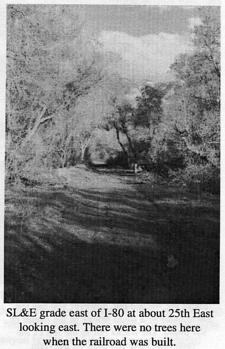
The tracks of the railroad ran down 11th East all the way to what is today 21st South where the Sugar House sugar mill stood. The mill stood on the bank of Parley's Creek at the south east corner of 11th East and 21st South where the Keith o'Brian building stands. This building is to be torn down in the near future to make way for a business mall. This area was the site of both the mill and the railroad interchange, as well as several other businesses including a large lumber mill on the south west corner of 21st South and 11th East, an ice plant east of the mill and later, a large laundry. It is here that one can first find grades of the SL&E. On both creek banks you can see old grades at places as the narrow gauge used one side and later the standard gauge used the other. The south line originally continued south on 11th East but went straight south behind the old Utah Light and Railway sub station (still standing). The tracks only came up about twenty years ago and the grade is easy to find. It ran along the west side of the Graystone apartments. The fence on the north end is curved to follow the grade.
The line ran to Interstate Brick which is now the Brickyard Mall. It kept to the west property line which is now the west end of the parking lot. Across 33rd South you can find the old narrow gauge grade angling south east on the west side of a small real estate office. On the west side of the old grade is an old irrigation canal. The track was laid on the embankment of the canal. The old grade is intact for about 900 feet but the original grade ran to Mill Creek and just ended as the line was never completed. The end of track was where Highland Drive crosses Mill Creek.
The main line to Park City started at the Sugar House mill and ran east along Parley's creek into todays Sugar House Park. This was the site of the Territorial Prison which stood on top of the hill to the north of the creek. It was here that polygamists were imprisoned and the controversial Joe Hill was executed. Originally, 13th East ended at 21st South, but later a large wooden bridge was built to carry the road over the tracks and the stream. The bridge stood until the tracks were taken up in the 1960's.
East of the park the tracks entered the Salt Lake Country Club. They followed the stream all the way to the east end of the golf course. In the 1950s and 1960s it was quite a sight to see trains winding through Salt Lake's most beautiful and exclusive golf course! The grade can be found here, but you may need to let the odd foursome play through! The Country Club is fairly new, and this was open country when the line was built. There was a large ranch with several buildings in the bottom of the canyon at 20th East.
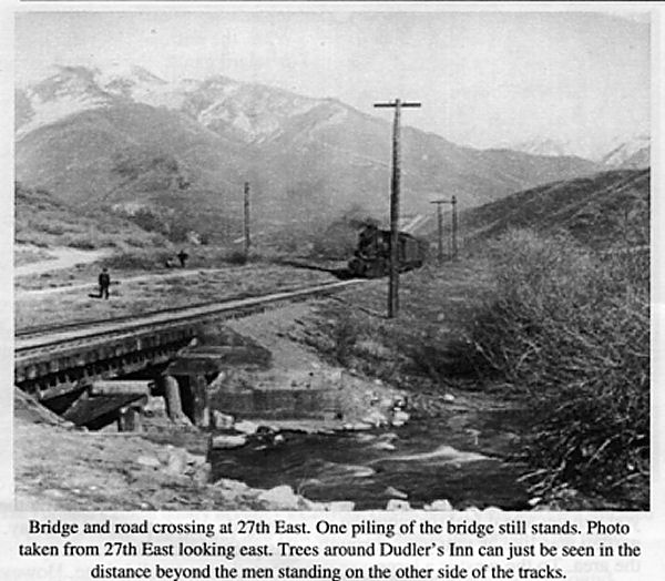
East of the golf course, the tracks crossed over the stream on a small bridge. They also crossed the road to Park City here. The road enters the canyon on the south side at today's 27th East. You can walk down into the canyon on the old road. This area is now a county wilderness park known as "The Gully." The old road has an interesting history. It was built in the 1840s by Parley Pratt long before the railroad. He operated it as a toll road which ran all the way to Parley's Park in Park Valley. (Park City was built in a small canyon to the south east of the valley when silver was discovered). Before the road was built, Parley's Canyon was not passable by wagons, and all traffic into the Salt Lake Valley crossed out of that canyon over to Emigration Canyon at Little Mountain (about 5 miles up the canyon).
Before Parley Pratt built his road, the canyon known as Obekokechee or "the big canyon" so named by the Indians. The road was called "The Golden Road" which was so named for the golden sandstone cliffs at the mouth of the canyon, not for any riches found there. However, Pratt saw more than a little gold after building the road as he charged between 1 and 25 cents for everything that moved up or down the canyon, which was almost everything that entered or left Salt Lake City.
The road was sold by Pratt in 1852 and rebuilt by the Mormon Church. The road was later sold to a group of auto companies in 1914, and became part of the Lincoln Highway, a coast to coast toll highway which ran from Washington D.C. to San Francisco. It only operated for about a year before the government decided to put a stop to interstate toll roads. They condemned the Lincoln Highway, making it part of the new federal highway system. It became part of US 50 and later US 40. Today these roads have become Interstate 80. Ever since Pratt built the road in 1840, it has been the only major route into Salt Lake from the east.
Many people mistake the old road for the railroad grade. The railroad grade is on the north stream bank. The old road is on the north side but higher on the hill. The grade is in perfect shape, and if you look hard you can find spikes and even ties which are still in. One bent of the bridge at 27th East is still standing in the stream. There are many concrete slabs, footings and walls here. Also, a tar pit is next to the grade walled in concrete. What it was and how it was used is a mystery. The excavation in the south side of the canyon was a strip mine dating from about the 30s, and the loading area can be found just east of the tar pit. There was a stub siding to the south.
There are other interesting non-railroad features here. On the south side of the old road you can find the site of Dudler's Inn and Beer Garden, which was a favorite stop on the old road. The foundation was the inn building and to the east the large retaining wall is the south side of the beer garden. The large trees are part of the beer garden, and you can get a real feel for what the garden was like as you walk through the area. To the west is a large arched stone aqueduct which brought drinking water down from a small reservoir at Suicide Rock. The aqueduct was built in 1888. There is also a foot bridge built of stone across the stream just below the site of the old dam at Suicide Rock.
The grade to the north of Suicide Rock is the old road (the railroad grade being gone here). The railroad crossed the stream to the south bank just below the dam and climbed a steep grade on the south side of the reservoir. This grade is now under the freeway.
The freeway is so wide and the canyon so narrow, that not much railroad grade can be found in the lower canyon. Some of the old road can be found as well as some grade, but for the most part everything is gone. The Portland cement quarry is still here and even still used to some extent by the highway department, but the buildings are all gone.
The most interesting grade can be found just above Mountain Dell golf course. The grade can be found on the south side of the golf course heading up toward Lam's Canyon.
When the railroad was rebuilt to standard gauge, the new track was laid on the old grade everywhere except for the section over the summit from Lamb's Canyon to Gorgosa. The narrow gauge track climbed a very steep grade (about 8 percent) and had a switch back. This was unacceptable for the standard gauge.
The switch back was used to avoid building a large bridge at Lamb's Canyon. Because the track had to climb high up on the side of the canyon to avoid the steep grades on the bottom of the canyon, at Lamb's Canyon it would need to cross on a very high and wide trestle across the mouth of the canyon. To avoid building such a bridge, the track turned up into Lamb's Canyon for about a quarter of a mile on the west side where the road is today. At this point the creek was easily crossed on a small bridge. However there was not enough room to turn any train. A helper engine was cut in on the back and trains backed across the bridge to the east side of Lamb's Canyon and continued backing for about 3/4 of amile up a steep 8 percent grade. A retaining wall still stands at the site of the bridge in Lamb's Canyon and the narrow gauge grade on the east side of the canyon is intact for about 900 feet.
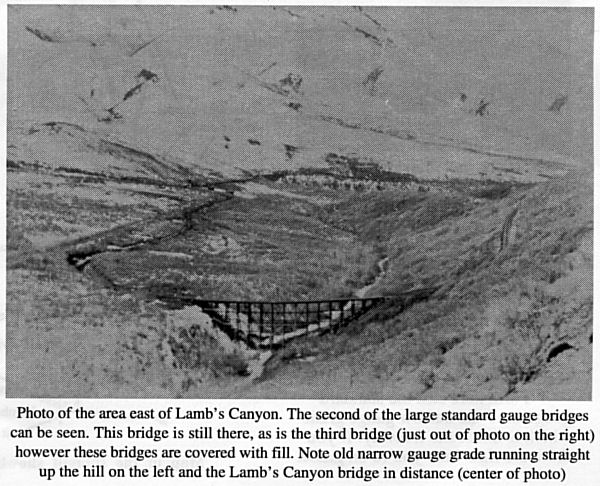
The standard gauge needed to build the necessary high bridge across Lamb's Canyon which was one of three large bridges built. The freeway covers the site of the Lamb's Canyon bridge, however a small section of the grade which approached the bridge can be seen above the road on the west side of Lamb's Canyon. About a mile further on, the standard gauge grade reemerges from under the freeway on the north side and parallels the freeway for about 1/4 mile. It then turns north and crosses Parley's Canyon on a large fill.
About two miles of grade winds its way up the north side crossing another large fill on the side. These two fills were originally the two other large trestles on the standard gauge. In fact, the trestles are still there under the fill! When the Rio Grande took over the line they decided to replace the trestles with fills, so earth was dumped over the sides of the bridge covering the bents. As near as can be figured, once the fill reached the stringers, the ties and stringers were removed and fill dirt added to the level of the track, which was then re-laid on the top of the fill. Today the top of the fills are eroded away and hundreds of bolts, nuts, spikes and retainers are scattered over the top. Some day erosion will uncover the bents. This grade is walkable and a wonderful hike. Check it out, the view from the top is incredible!
The narrow gauge backed straight up the south side of the canyon (where the freeway is now) for about 3/4 of a mile. It then backed into a wye and trains pulled forward and continued up the canyon on 8 percent grade to the summit. At the summit the tracks turned south following the natural canyon. Here the freeway crosses the summit in a deep cut. The old narrow gauge grade can be found emerging from under the freeway and crossing the hill to the south. At this point there was a wye to cut out the helper engine, with a small shop for the helper on the west leg of the wye.
The narrow gauge then crossed back to the north side of the canyon on the east side of the summit and headed down grade at 8 percent.
The standard gauge crossed under the summit through a short tunnel. The entrances of the tunnel have been filled to keep people out. However the west portal can be easily found right next to the freeway in the bottom of the canyon. The tunnel has filled with water and is seeping through the fill and out into the canyon. The filled-in east portal is now in someone's yard. This tunnel was quite an engineering problem as the soft earth kept caving in despite a wooden tunnel liner. The final liner is several feet of concrete. Also the earth removed from the tunnel was so compacted that it expanded over night to the point that it was overflowing the gondolas it which it was loaded. Weird.
Much of this grade is intact but some has been destroyed by freeway, road and home construction. The best narrow gauge grade is on the west side of the summit where it crosses over the mouth of the standard gauge tunnel. (The only spike I have found on the narrow gauge I found here). The summit wye can be found and a small part of the narrow gauge grade on the east side of the summit can be found, but it is very over grown.
About 1/2 mile east of the summit both the narrow gauge and the standard gauge grades emerge from the north side of the freeway. The narrow gauge heads straight down the hill on 8 percent grade and ends back under the freeway. The standard gauge follows the hillside heading north and ends up way back in Jeremy Ranch golf course. (The third time this railroad goes through a golf course.) It is drivable in a four wheel drive.
The two grades come together at Gorgosa. The Gorgosa "station" stood where the west bound off ramp is, now the Gorgosa - Jeremy Ranch exit. To the south of the off ramp is the Buzzo siding. This was a stone quarry on the narrow gauge. The quarry is easy to find and there is an old sandstone building still standing
The grade emerges from under the northeast side of the freeway just west of the Park City exit. The grade runs through some houses but is easy to find for a short distance. It then ends up under the road until it makes a turn to the south and crosses Parley's Park. No houses have been built in this part of Park Valley (as yet) and the grade is easy to find. The grade runs straight to the base of the hill and then follows the foothill until it ends up under the new highway into Park City. It reemerges where the highway curves toward town. The grade can be found about 300 ft. to the left and parallel to the highway all the way into Park City. In the city the grade is totally gone and all that remains is the Rio Grande freight station, which is now a real estate office. The UP interchanged here, and the UP station also still stands. The UP grade is now a hiking trail all the way to Coalville.
###